Your current well is the job. The offsets are there to help you drill it.
The current well comes first: last accepted survey, projected bit position, gamma response, active target, and current drilling characteristics. Historical wells are there to sharpen the comparison.
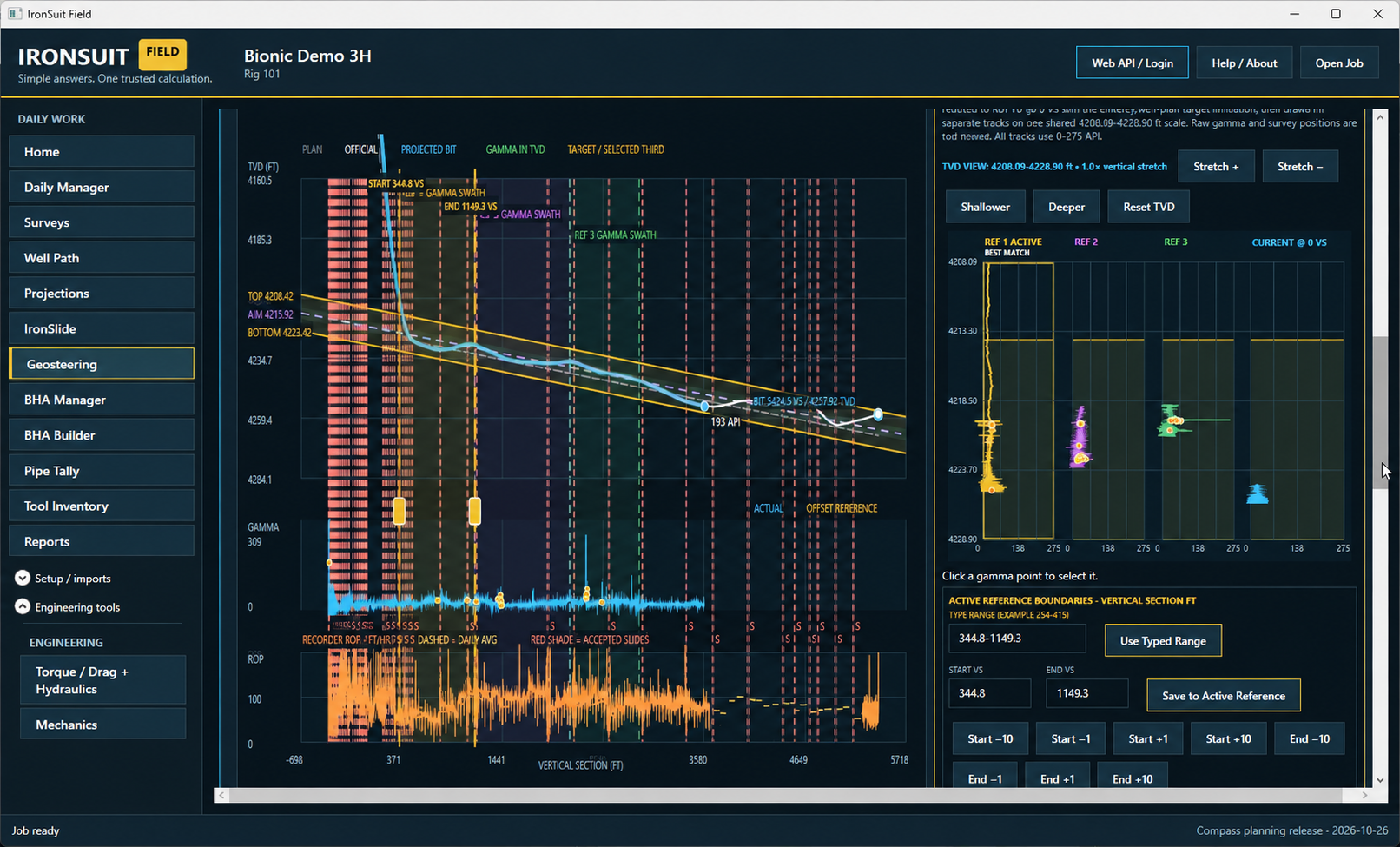
You can fill a screen with every well in the basin and still give the DD nothing useful. A cloud of dots may look impressive in a sales meeting. It does not tell you what the well you are drilling is doing right now.
This well has its own path, BHA, lithology, dip, gamma response, drilling characteristics, and history. An offset matters when it helps explain something about this well. If it does not, it is just another line on the screen.
Show me how my well compares to the right wells, in real time, while I can still use the answer.
A scatter plot is not a steering decision
Portfolio analytics has a place. Use it for planning, benchmarking, and post-job review. But while I am drilling, I need to know where the active well sits against the plan, the target, the gamma response, and the offsets that actually mean something here.
The live questions are straightforward. Where are we? Where should the bit be? What changed since the last survey? Does the current gamma and trajectory response agree with the structure we expected? Which offset helps answer that question?
If the geosteering specialist has to leave the well, dig through another system, and explain the result over the phone, the useful part is in the wrong place.
Do not lose the well you are drilling
The active path, last accepted survey, projected bit position, target window, gamma, ROP, slides, and rotary performance should hit you first. The offsets are there beside it to help explain what you see.
That is why IronSuit keeps the current well in front. You should never have to hunt through a forest of historical traces to find the well that is costing money right now.
What belongs in the current-well review
- The position at the last accepted survey and the projected bit position, with projection assumptions visible.
- The active plan, target, and boundary context being used for review.
- Current gamma response, interpreted lithology and formation structure, and drilling characteristics.
- The few historical wells that actually help explain the active interval.
- Where the comparison is strong, where it is weak, and where the offset stops matching.
- The name and interval of the reference being used.
The nearest well is not always the right well
A nearby well can be a lousy comparison. A well farther away may tell you more about the dip, gamma character, BHA response, or tendency you are seeing. Distance is one part of the question, not the answer.
Use only the customer-approved offsets that matter to the current well. Keep the source well and interval visible so everybody knows what is being compared.
An offset is a reference, not an answer
Historical gamma, path behavior, target relationships, and drilling characteristics help the team ask better questions. They do not drill the current well for you.
Used correctly, an offset helps you say:
- This current response resembles a prior pattern worth reviewing.
- This part of the current well does not agree with the selected reference.
- The reference supports one interpretation, but the directional evidence remains incomplete.
- Current gamma, lithology interpretation, or drilling response has departed enough from the reference to require reassessment.
Used badly, it turns into: “The offset did it, so this well has to do it too.” That is how a useful reference becomes a bad assumption.
Know which well you are comparing against
Use the wells the customer has cleared for the job. Keep the source well, interval, and reason for using it attached to the view so the next person knows exactly what they are looking at.
When the screen moves from the field to the office, that information needs to move with it. Nobody should have to guess which offset a trace came from.
The people still do their jobs
The geosteering specialist interprets geology and target position. The directional driller works the trajectory. The rig driller runs the rig. IronSuit keeps the same well in front of everybody.
That cuts down the phone-tag, the screenshots nobody can identify, and the arguments caused by people looking at different versions of the job.
Use history to understand this well. Never let history make you stop watching this well.
The best geosteering screen is not the one with the most wells on it. It is the one that helps the team understand this well right now.